I used to think maps were basically finished. Like someone had driven every road, photographed every intersection, uploaded it all, and the job was done. The ongoing work was just maintenance, touching up a pothole here, adding a Starbucks there. Then I fell into a research rabbit hole that wrecked that assumption in about fifteen minutes.
The thing that got me was a single realization: the majority of road data updates in 2024 didn’t come from camera cars or satellites. They came from phones. Ordinary smartphones in ordinary pockets, quietly feeding GPS traces back to map providers every time someone drove to work or walked to the grocery store. Your phone is doing survey work right now, and nobody asked your permission in any way you’d remember agreeing to.
That changed how I think about every map I open.
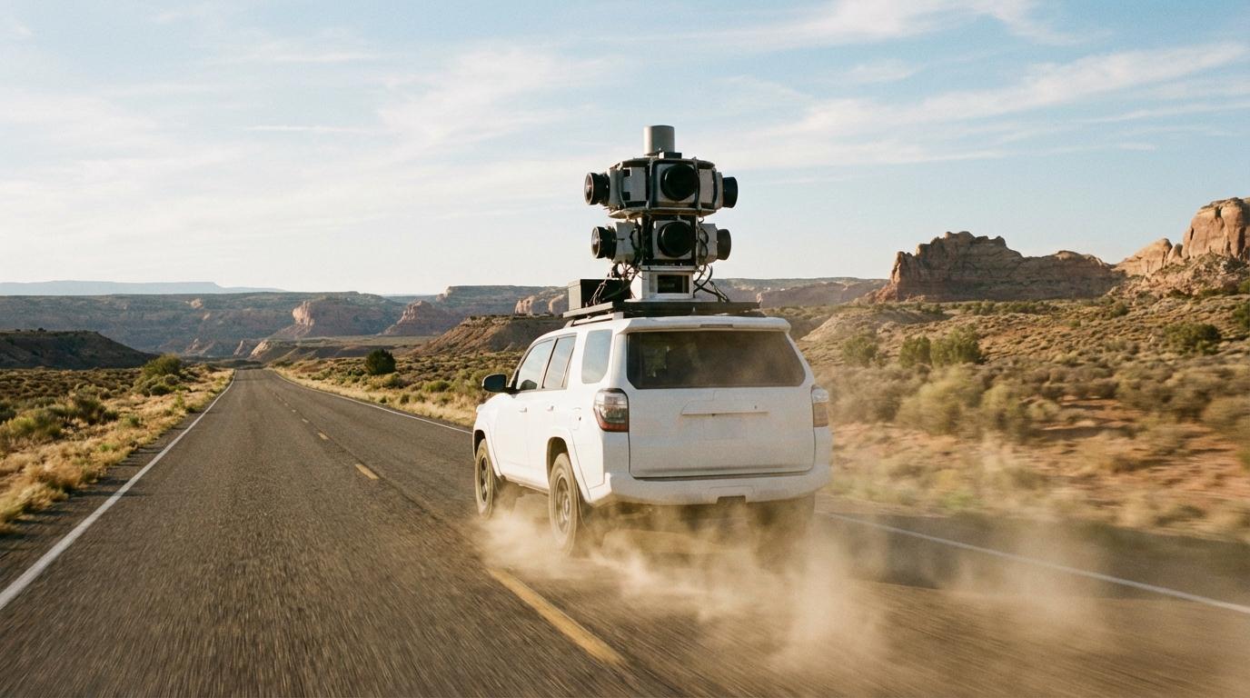
Camera Cars Are the Headline, Not the Whole Story
Google, Apple, and a handful of other companies run fleets of vehicles outfitted with multi-lens cameras, LiDAR, and precision GPS. You’ve seen the cars around town, the ones with the awkward roof-mounted rigs that make them look like insects. They drive roads, record everything, and produce centimeter-accurate 3D models of road geometry, including lane widths, sign positions, curb heights, and median types.
What surprised me is how little of the map that actually covers.
These fleets re-survey dense urban corridors every year or two. But rural roads, exurbs, newly built subdivisions? Some of those have been driven exactly once. Others haven’t been driven at all. A camera car can only be in one place at a time, and there are roughly 4 million miles of paved road in the US alone. Even with hundreds of vehicles running simultaneously, the math doesn’t favor completeness. It favors triage: map the roads that the most people use, and let the rest age.
That triage is why you’ll sometimes navigate to a cabin or a lake house and find that the last half mile of the route is either wrong or missing entirely. The road exists, but nobody with a LiDAR rig has driven it since it was paved. If you’ve ever dealt with that problem while coordinating a group, you know the headache. (If your destination doesn’t have a proper street address at all, there are ways around that, but they require planning ahead.)
Your Phone Is the Real Cartographer
This is the part that genuinely surprised me, and it’s worth spending some time on because the scale is hard to believe until you actually trace how it works.
Every time you drive with a mapping app open (or even just with location services enabled), your phone transmits anonymized GPS coordinates back to the provider. Google calls this “probe data.” Apple collects a version of it. So do Mapbox, HERE, TomTom, and basically every navigation platform. The pings are stripped of personal identifiers, aggregated, and analyzed for patterns. If enough phones suddenly deviate from a known route, the system infers something changed: a road closure, a new one-way restriction, construction forcing a detour.
The scale is staggering. Over a billion devices feed GPS traces to Google Maps every month. Not a billion pings. A billion separate devices, each producing hundreds of location updates per trip. The aggregate dataset dwarfs anything a camera fleet could produce, and it updates continuously rather than on a re-survey cycle measured in months or years.
Here’s the technical aside that I think makes this click. When a map provider detects that, say, 15 phones deviated around the same point on a road within the same week, an automated system flags that location for review. It cross-references satellite imagery to check whether a new road appeared, whether a lane was closed, or whether a roundabout replaced a traffic light. Many of these changes get incorporated into the map without a single human reviewing them. The threshold for detection is surprisingly low; a handful of deviating phones is enough to trigger the process.
That means the map of your commute is probably accurate down to last week’s changes. But the map of a road with sparse traffic, the kind of road you’d take on a group trip to the mountains, might be months or years stale. The phone-based system only works where there are phones. No traffic, no data, no update.
I find this both impressive and slightly unsettling. The navigation I rely on every day is, at its core, a crowd-sourced dataset assembled from the location histories of a billion strangers. It works because of volume, not because anyone personally verified it.
Satellites Fill the Gaps (Sort Of)
Satellite imagery is the backup layer. Companies like Maxar and Planet Labs operate constellations of imaging satellites that photograph most of the Earth’s surface every few days. Machine learning models scan those images for new road surfaces, widened intersections, and demolished structures.
The catch is resolution. Satellites are good at detecting that a road exists, but not great at determining whether it’s one-way, what the speed limit is, or whether the surface is paved or gravel. Those details still require either a camera car or a large enough cluster of phone traces to infer traffic behavior. Satellite data establishes the skeleton of the map. Everything else adds the muscle and skin.
The Volunteers Nobody Talks About
OpenStreetMap has over two million editors worldwide. Most of them contribute casually, fixing a misplaced restaurant pin or tracing a new trail. But a subset of them are obsessives who spend hours tracing road geometry from aerial imagery, verifying it against GPS traces recorded on their own drives, and adding metadata like speed limits, surface types, and turn restrictions.
I came across a post from one of these editors that stuck with me. They described spending an entire weekend mapping a newly built subdivision because the developer hadn’t filed updated roads with the county GIS office, and delivery drivers kept getting lost. No one paid them. No company assigned the task. They just got annoyed that the map was wrong and decided to fix it themselves.
That kind of contribution is invisible to most users, but it underpins a surprising amount of the navigation stack. Apple Maps, Bing Maps, and several automotive navigation systems all draw from OpenStreetMap data in regions where their own first-party data is thin. The volunteers are, in a real sense, subsidizing commercial mapping products with unpaid labor, and doing it out of a combination of civic instinct and the particular satisfaction of making a map correct.
Government Data: The Foundation You Never See
Underneath all of this sits government-maintained road data. In the US, the Census Bureau publishes TIGER/Line shapefiles that define the baseline geometry of every road in the country. State DOTs maintain their own databases of highway conditions, lane counts, and bridge clearances. Municipal planning offices track new developments and road modifications.
This data is public, free, and often out of date by the time it’s published. The lag between a road being built and a county GIS office updating its records can be anywhere from weeks to over a year. Map providers ingest government data as a foundation, then layer phone traces, satellite imagery, and community edits on top to catch what the bureaucracy missed. The result is a composite that’s more current than any single source, but less authoritative than any of them individually. When your cell signal drops, you’re relying on whichever snapshot of this composite your phone cached before you lost connectivity.
What This Actually Means When You’re Driving
The map on your phone is not a photograph of reality. It’s a statistical composite assembled from cameras, phones, satellites, government filings, and volunteers, each with different update frequencies, different accuracy thresholds, and different geographic coverage. High-traffic urban roads are mapped with almost frightening precision. Low-traffic rural roads are mapped with whatever data happened to exist when the last update cycle ran.
I used to get frustrated when navigation sent me the wrong way or didn’t know about a new road. Now I’m more surprised that it works as well as it does. The fact that a billion phones collectively maintain a near-real-time model of most of the world’s road network is, honestly, one of the more underappreciated pieces of infrastructure we’ve built. It’s just that “most” is doing a lot of heavy lifting in that sentence, and the gaps tend to show up exactly when you’re somewhere unfamiliar and need the map the most.