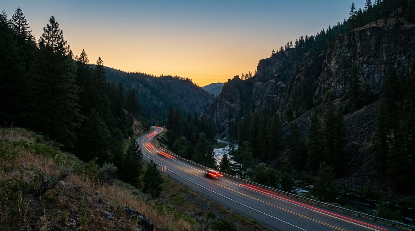
I was convinced GPS needed cell service until a canyon proved me wrong. My friend Amir was leading our four-car convoy into Kings Canyon National Park, and somewhere past the General Grant Tree area, every bar of signal vanished. I expected the blue dot on my phone to freeze, spin, give up. Instead it kept tracking me perfectly, sliding along the road in real time as we wound deeper into the canyon. Zero bars, but the phone knew exactly where I was, down to which lane of the road I was in.
That moment broke an assumption I’d held for years, and I started digging into why it worked. Turns out the answer matters a lot for anyone using Konvoyage on trips that cross through spotty coverage.
GPS and Cell Service Are Completely Separate Systems
Your phone’s GPS receiver captures signals from satellites orbiting about 20,000 kilometers overhead. Those signals arrive whether you have full LTE or absolutely nothing. The GPS chip is a standalone receiver that calculates your position by measuring time delays from at least four satellites simultaneously, and no cell tower participates in that math at all. This is why your blue dot kept working perfectly in that canyon: the satellites don’t care about your carrier.
What cell service actually provides is the data pipe. When Konvoyage sends your coordinates to the server, or when the server pushes back everyone else’s positions, that data rides on your cellular connection. Remove the pipe, and the GPS chip keeps working while the communication layer pauses. Your phone knows where you are. It just temporarily can’t tell anyone else.
There’s a common misconception worth clearing up here. Phones use something called Assisted GPS to speed up the initial satellite lock by downloading orbital data over cell networks. But once the receiver has locked onto satellites, losing cell service doesn’t interrupt that lock. Assisted GPS is a startup optimization. It’s not something your phone needs continuously. As long as you have a reasonable view of the sky, position accuracy stays the same regardless of what your signal bars show.
What Actually Happens Inside Konvoyage When Signal Drops
Three things respond differently when connectivity disappears, and conflating them is where most of the confusion starts. It’s worth walking through each one separately because the distinction between “broken” and “paused” changes how you prepare for a trip.
Position sharing pauses. Your dot on everyone else’s screen freezes at the last location you transmitted, and their dots freeze on yours. The WebSocket connection goes dormant, consuming almost no battery while it watches for the network to come back. When it does come back, the connection restores automatically and all positions snap to current locations without anyone touching anything. I’ll admit something: I didn’t fully understand how this store-and-forward reconnection architecture worked until I watched it happen in real time on that Kings Canyon drive. Seeing frozen dots suddenly jump to their correct positions within seconds of signal returning was one of those moments where the theory I’d read about finally clicked into something tangible.
Turn-by-turn navigation is conditional, and this distinction is critical. If you started navigation while you had coverage, the route geometry, maneuver instructions, and map tiles along your corridor are all cached locally by Google’s Navigation SDK. Voice prompts continue. Turn arrows appear on schedule. The map stays visible. But if you try to start navigation after signal has already dropped, the route request can’t reach Google’s servers, and you get nothing. The takeaway is simple: every car in the convoy needs to start navigation before entering a dead zone, not after.
Everything else persists. Your trip code, member list, destination coordinates, the app’s local state. None of that disappears during a disconnection. Konvoyage stores trip metadata on the device specifically so a temporary signal gap doesn’t force anyone to set things up again.
Missing a turn while offline creates an unpredictable situation that depends on how much map data was pre-cached around your route. Sometimes the Navigation SDK recalculates successfully from cached tiles. Sometimes it can’t, particularly if you’ve strayed far enough that the cached area no longer covers your position. There’s no reliable rule of thumb for this, which is why following the route exactly through dead zones and saving spontaneous detours for areas with coverage is the safest approach.
Complete dead zones get the most discussion, but partial coverage is what you’ll actually encounter most of the time: a weak signal that drops and recovers every few minutes, or a sluggish fallback connection that loads nothing except the smallest data packets. This is where Konvoyage has a quiet advantage. A single position update is roughly 200 bytes, about the same size as a text message. Compare that to loading a single photo on social media, which requires thousands of times more data. Because Konvoyage’s packets are so small, the app frequently maintains functional tracking in conditions where everything else on your phone appears dead. Updates might arrive less frequently, and dots might jump rather than glide, but the positions stay current enough to know where everyone is. When your group chat has gone silent and streaming cut out ages ago, those tiny WebSocket packets often still squeeze through.
Before entering a zone you know has no coverage (and cell carriers publish coverage maps that are remarkably consistent trip to trip), the preparation checklist is short. Every car starts navigation while still in coverage. Download offline maps for the region in Google Maps, since the cached tiles benefit the underlying SDK that Konvoyage uses. Agree on a physical meeting point past the dead zone, described by a landmark rather than a pin drop that requires data to render. And brief the group on the plan: if someone gets separated, continue to the meeting point instead of pulling over to wait for signal. That last point prevents the most common problem, which is panicked drivers scattering at random intervals through a canyon with no way to communicate. A pre-agreed gas station or trailhead on the far side removes the guesswork. If you’re planning trips through mountain terrain where signal is already unreliable, building dead-zone preparation into your trip planning makes the whole thing feel less like separate checklists and more like a single coherent strategy.
The Kings Canyon Reconnection
Back to that October drive. Four cars, roughly eighteen minutes of frozen dots on everyone’s screen. Headlights in the rearview mirror were our only confirmation the group was still together. Then we rounded a bend and my phone grabbed a single bar of signal.
Every dot snapped to its real position along the canyon road within seconds. Amir was up ahead in his Subaru, exactly where his taillights said he’d be. The two cars behind me were spaced out at comfortable intervals. Nobody had pulled over, nobody had panicked. The only comment anyone made afterward was that Amir takes mountain switchbacks too fast. For a trip where hours of canyon driving meant navigating to a campsite with no real address, the brief signal gap ended up being the least interesting part of the drive.
If your trip involves genuinely off-grid terrain where entire days pass without signal, Konvoyage isn’t the right tool for that specific problem. Satellite communicators exist for that use case. But for road trips that cross through dead zones, which describes the vast majority of remote driving, the pattern is predictable: GPS keeps working, position sharing pauses briefly, and everything reconnects on the other side. The app handles it. You just need to make sure navigation is running before you lose signal.